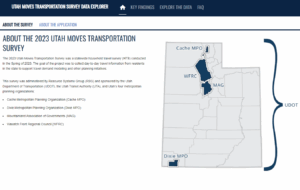
Models and Forecasting
Models: Tools for Forecasting the Future of Our Region
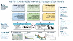 WFRC employs sophisticated transportation and land use modeling tools that help support decision-makers, agency staff, and the public with plausible, insightful forecasts to best inform planning for our Region. The primary tools are the Wasatch Front Travel Demand Model and the Real Estate Market model described below. Together these models enable detailed analyses and comparisons of how well the transportation and land use plans that implement the Wasatch Choice Vision perform, as well as other possible future scenarios for our region.
As transportation and land use are mutually dependent, forecasting for both of these regional components must work in tandem in order to optimally support the development, selection, and prioritization of future transportation projects intended to meet future needs. Similarly, the integrated WFRC/MAG modeling tools are useful for exploring local land use policies such as those that promote city and town centers.
Projected measures produced with assistance from transportation and land use models include:
- future population, household, and employment distributions;
- travel patterns and mode share;
- future vehicle and transit volumes and their relationship to the capacity of existing
- facilities and services;
- travel times and comparative accessibility to workplaces and other key destinations; and
- key inputs to air quality mobile-source emission models
Developing and maintaining travel and land use models is a best practice for regional planning. But it also fulfills requirements and expectations needed to continue to receive our region’s share of federal transportation funding. Accordingly, WFRC’s modeling processes comply with federal law (FAST Act, MAP21, and Clean Air Acts) as well as guidance provided by the US Department of Transportation (USDOT), the Federal Highway Administration (FHWA), the Federal Transit Administration (FTA), and the Environmental Protection Agency (EPA).
WFRC, MAG, UDOT, and UTA are planning to begin a multi-year project to implement an Activity-based Model (ABM) representation of regional household travel within the WF-TDM regional model. Toward this end, the partners worked with RSG, Inc. to develop this ABM Implementation Framework document which provides background, design recommendations, anticipated input data requirements, and an exploration of the development project scope, schedule, cost, and training needs. WFRC expects to begin a procurement process for model development consultant services later in 2025. Further project details will be provided within the procurement process. After which, periodic updates will be provided to stakeholders as the anticipated 3 year project progresses.
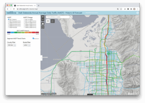
Wasatch Front Travel Demand Model: Future Traffic Conditions and Transit Ridership
 Since 2000, WFRC has partnered with our Mountainland Association of Governments (MAG) to develop and support a shared, regionwide travel demand model called the Wasatch Front Travel Demand Model (WF-TDM).
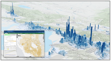
The WF-TDM is a modified 4-step “trip-based” travel model that incorporates a travel time feedback loop in order to evaluate roadway congestion costs in its distribution of trip origins and destinations and its travel mode choice modules. The model calculates roadway volumes, travel speed indicators, transit route boardings, and regional statistics including vehicle miles traveled (VMT), vehicle hours traveled (VHT), transit/auto/non-motorized mode shares, and trip length costs.
The travel model includes the phased, fiscally-constrained 2023-2050 RTP roadway and transit projects and the official traffic analysis zone (TAZ)-level socioeconomic forecasts for the Region. WFRC and MAG have calibrated the model’s parameters to reflect local travel behavior patterns reported in the Utah Travel Study household survey (trip rates, trip lengths, time of day of trip, mode of travel, etc.) and validated the model’s results with observed travel conditions (transit ridership, roadway volumes, and roadway speeds) for the model’s base year, 2019. Additional processes, including external review, are used to validate the reasonableness of future year travel projections.

WF-TDM Online Documentation
The WF-TDM is under constant development. Various versions and iterations of the model exist, with the most relevant described below:
- v9.2.0 — current version of the travel model; reflects the Amendment #4 changes to the WFRC Regional Transportation Plan
- v9.1.1 — reflects the Amendment #3 changes to the WFRC Regional Transportation Plan; a supplemental socioeconomic forecast for the MAG area of the region (Utah County); an updated Workplace Access to Opportunity (ATO) calculation methodology; and updates to the accompanying Viz Tool for exploring model results. (released May 27, 2025)
- v9.1.0 — reflects the Amendment #2 changes to the WFRC Regional Transportation Plan and draft Amendment #2 to the MAG Regional Transportation Plan; inclusion of the vizTool data viewer
- v9.0.2 — reflects the Amendment #1 changes to the WFRC & MAG Regional Transportation Plans (adopted May/June 2024)
- v9.0.1 — minor updates and bug fixes to the v9.0.0 model
- v9.0.0 — base for the current version of the travel model; foundation for the current traffic volume forecasts for the Wasatch Front Region; adopted as the official version of the 2023-2050 RTP on May 25, 2023
- v8.3.2 — previous version of the travel model; foundation for the previous traffic volume forecasts for the Wasatch Front Region; released on February 2, 2022
Detailed documentation for each of the model versions is described in the online documentation.
Currently, WFRC is undergoing the development of v9.2. These versions will introduce mode choice and truck model enhancements as well consideration of the 2023 household travel survey.
Contact
To request a copy of the current or previous model, please contact

Suzie Swim
Data Scientist
Real Estate Market Model: Where Will We Live and Work in the Future
 The Real Estate Market Model (REMM) relies on best available resources to project future residential and employment-related development activity using the UrbanSim modeling platform. In order to accurately model future years, REMM is first calibrated to best reflect the base year of the adopted RTP, currently 2019. Critical inputs to REMM’s consideration of available land and profitability of new and redevelopment activity include:
- A region-wide parcel land use and valuation database;
- An inventory of local government general plans;
- The results of a multi-year scenario-based visioning exercise;
- A synthesized household population dataset for the model’s base year (2019) based on Census data;
- Address geocoded employment totals from the Utah Department of Workforce Services (DWS);
- County-level employment and population control total projections, sourced from the University of Utah’s Kem C. Gardner Policy Institute;
- Public and private sector expert advisors; and
- ‘Physical constraint’ map layers that depict areas where future development is prohibited or not practical due to steep terrain, wetlands, mining, or public lands (formal designations or ownership).
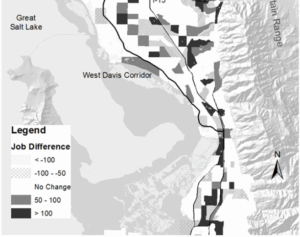
These household and job distribution projections inform future trip generation in the regional TDM. And in turn, REMM factors travel accessibility derived from the travel model into its predictions of land development activity.
The current version of REMM is v2.x
REMM Documentation
WFRC and MAG hosted a expert peer review of REMM and its related processes in August 2019. Three land use modelers from comparable MPOs (Albuquerque, Detroit, Phoenix) were provided with REMM 1.0 documentation in advance of a 2 day in-person review seminar that featured presentations from and discussion among the panelists and WFRC/MAG area stakeholder agencies. The review concluded that REMM is well within best practices for land use modeling and recommended potential future areas of enhancement (view 2019 REMM Peer Review report).