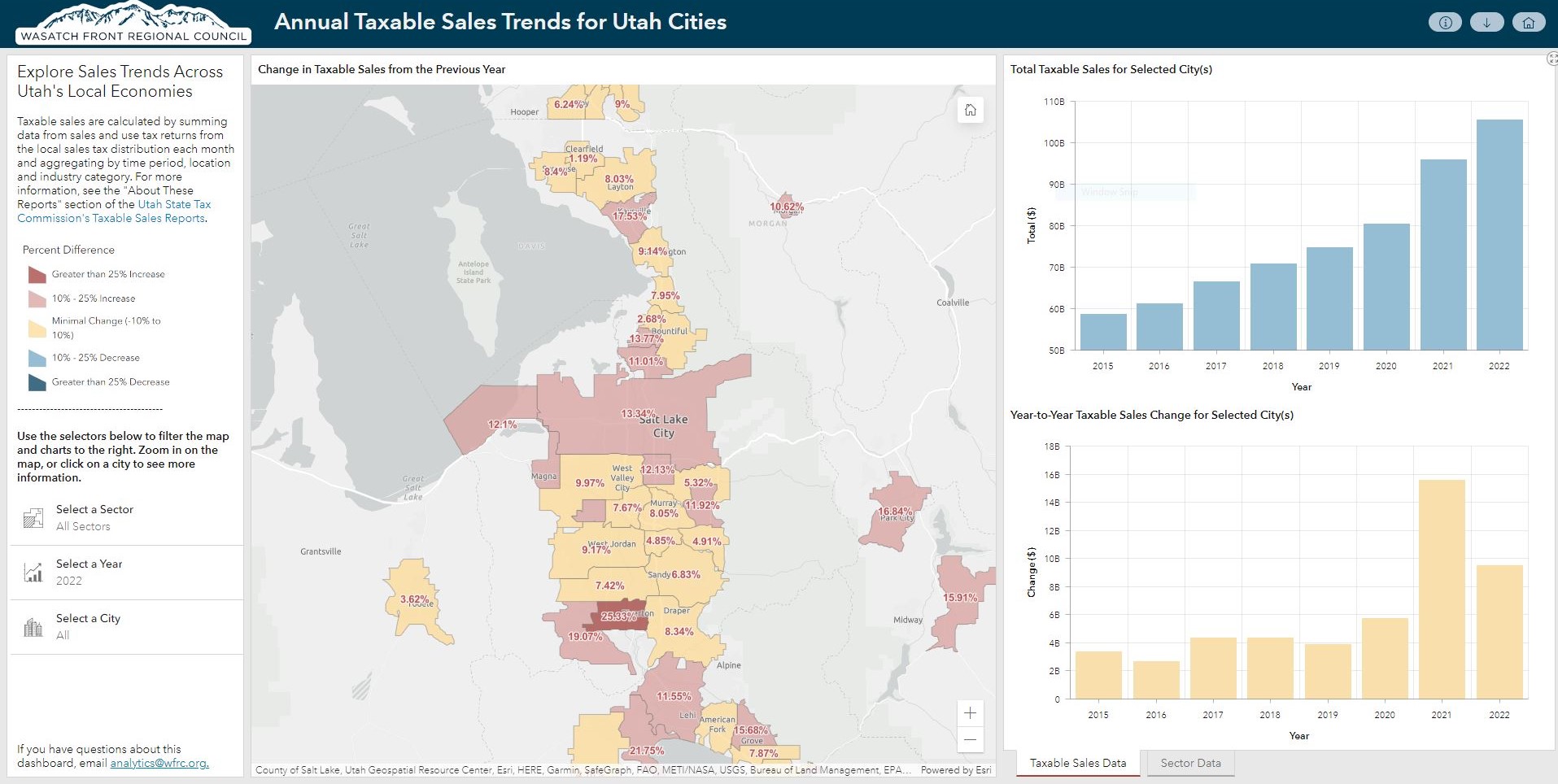
Explore Sales Trends Across Utah’s Local Economies

Compare year-to-year taxable sales between 2015 and 2022, using data from the Utah State Tax Commission (USTC), for mid and large-sized cities. This new dashboard is an upgrade to our previous COVID-era taxable sales map, so you can view these trends in a more interactive fashion.

Transportation and Land Use Connection (TLC) 2023 Awards Announced

This year’s total TLC program funding awarded approximately $2.1 million from the intergovernmental partnership, with local matches equaling approximately $260,000, for a total region-wide funding amount of $2.4 million – a record high, reflecting the significant demands growth is placing on our communities.

Map of the Month: Household and Jobs Forecast Web Map

Where to call home? In choosing a location to live, cost factors into almost every household’s decision. There’s the cost of owning or renting your home, and the cost–in time and money–of the trips you’ll need to make, some of them nearly every day. Housing and transportation are the two biggest household expense burdens and have a significant impact on a family’s financial outlook. The Wasatch Choice goal “Housing Choices and Affordable Living Expenses” is stated broadly to acknowledge that much more goes into determining affordability than just housing expenses.

Fall 2022 Wasatch Choice Workshops

Thank you to our transportation partners, local communities, and stakeholders for the input over the last few months on the draft fiscally constrained 2023-2050 Regional Transportation Plan (RTP).

Map of the Month: Household and Jobs Forecast Web Map

WFRC’s current household and jobs forecast update is expected to be finalized in May of 2023 and will be used in conjunction with transportation investment decisions and other local and regional planning work. But you don’t have to wait until then to start exploring this current update at the TAZ and ‘city area’ levels in our Household and Jobs Forecast web map.

Map of the Month: Expanded Housing Suitability Calculator

the Housing Suitability Calculator tool lets you decide what criteria are most important for siting new housing and then does the calculations and mapping to show you how well locations your areas of interest perform in terms of ATO.

Map of the Month: Utah Healthy Places Index

Whether you want to explore your neighborhood or a spot for your next Utah outdoor adventure, our September map of the month, atlas.utah.gov, is a great general purpose map viewer

Map of the Month: atlas.utah.gov

Whether you want to explore your neighborhood or a spot for your next Utah outdoor adventure, our September map of the month, atlas.utah.gov, is a great general purpose map viewer

August Map of the Month: Weber County Housing Suitability Map

Our August Map of the Month highlights a new interactive map that allows users to set their own criteria to create a custom housing suitability map for any single city or combination of cities in Weber County. We’re working to provide similar information in a region-wide map expected later this year.